Moderator of this page: Maya Tolstoy
What is available?
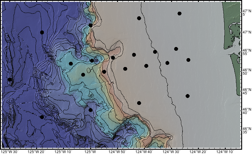
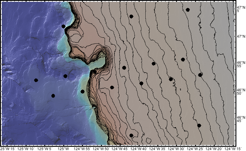
Above two plots showing bathymetry in the area of the FA along with proposed site locations. One shows 100 m contours, with the other showing 10 m contours out to 300 m (the range for LDEO rov recovery). The LDEO trawl resistant OBSs are only going to be deployed out to 1000 m, so they will not quite complete the FA this July, with the outer 3 being deployed in October.
I think the existing bathymetry looks pretty good (these plots are from geomapapp), at least for the shallower sites. I have emailed Chris & William to ask if I’m missing anything here.
Overall, the coverage at the shallow sites seems very good except for the two northern most sites which I am assuming are in Canadian waters (see below). One of these two might be shifted slightly to get into the better bathy areas also.
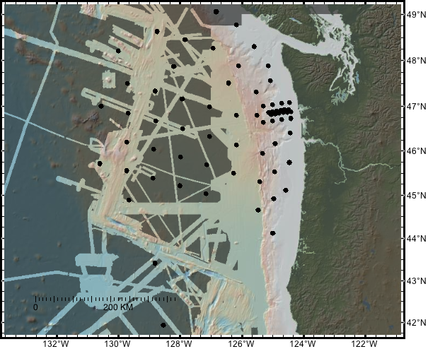
Adding Chris Goldfingers map here since I can’t figure out how to get it into the discussion below…
Contents
Discussion
Comments from site migration
On Mar 21, 2011, at 7:35 PM, Chris Goldfinger wrote:
Maya and all,
Ok, even thought some of the deployment is sooner that we thought, it still shouldn’t be a problem to choose specific sites based on the new Thompson bathy, which will be available at the end of June. Some exists now in usable form. I should point out that the focused array runs across an area at the canyon head that may host some rather fragile glass sponge reef patches. Lot’s of folks in NOAA are quite excited about these as a canary species….The northern canyon rim is a known site that we mapped with NOAA last year, though a detailed map of the southern rim (where the array goes) doesn’t yet exist. Bottom contact fishing, (though not trawling) is allowed there, so that would be longline traps, which probably are similar to an OBS in their footprint.
Cheers, Chris
Some very helpful emails from Chris Goldfinger in response to my inquires about the bathymetry and sending the above plots:
Hi Maya,
Some comments…. The Geomap images seem to be colored in in areas where there is almost no data. The two figures centered on 46 55N have very little data other than the NOS soundings, and a few random multibeam tracks. You can’t really tell that easily from the image though, it looks “good”. The other two figures give the impression that the slope is covered in WA, which is not the case, and not true in Canada either. The grid in the regional figure is some amalgam of limited multibeam and sparse soundings, i.e. mostly fiction, except for the ridge areas, areas south of 46N and deeper than ~ 600m, which are real multibeam. Most of the Cascadia shelf and upper slope is not surveyed. Attached is the real map of WA multibeam coverage that is close to up to date. One significant Canadian cruise (TN 175) is missing, and are few little things. The lighter areas are covered, the other blue areas are just soundings.
The planned Thomson cruise is designed to fill in much of Washington, and cover all OBS sites not covered by at least pretty good multibeam, so we’ll need to coordinate closely. The cruise is May 28-June 25, and we will be creating regional surfaces from all existing data and the new data while at sea, including the Canadian slope and two passes for shallow instruments on the shelf (if the clearance can be processed in time, it’s in progress). When is the deployment? I’ve been hearing September, leaving plenty of time so hope that’s right.
There is a lot of data not in geomap app, it’s sort of been a hobby of mine to collect it and we have most everything there is, and will be collecting more this summer in addition to the Thomson cruise. On the shallow shelf, there are many trawl prohibited areas already in existence that would be great for deployments, they are called RCA’s, rockfish conservation areas here are many of them, they’re large, and are coast wide. Do you know about these? I can send you the boundaries if not. But in any case, we’ll need to coordinate this plan in detail before the Thompson departs in May.
I’m a bit wrapped up in the Japan earthquake at the moment, but Chris Romsos (my hydro tech) is working on this.
Cheers, Chris